Still wandering around the IFSC/Docklands in Dublin. Adjacent the Ring of Stones– from a previous post is Georges Dock. It was built back in 1821 and named after one of those German lads that sat on the throne over in England. Both the main Dock & the Inner Dock which was built three years late in 1824 are fairly dry these days. The wee pedestrian bridge is obviously a much later edition to the area and carries people and vehicles over what I can only describe as a lock, like what you might find at regular intervals along the canals. There is even a winding mechanism on either side, although I would not be too sure that they would still work. There is no sign of any recent use.
The Area around the docks is home to a number of other items of interest The Irish Emigration Museum in permanent residence. The local City Council have also used the area for various events including the annual Oktoberfest. There was even talk a few years ago of turning it into a white water rafting facility, but the council voted against the idea. That said it would be nice to see the waters return.
Out and about doing my thing after work yesterday, got chatting as it happened to a fellow amateur photographer. We eventually got chatting about the age-old topic. ‘’What do you carry in your Camera Bag’’? So this morning I was still thinking about the subject. I’m only back shooting four to five weeks and the brand-new bag I got on Temu is already bursting at the seams. Do I really need to be packing this much luggage when I’m out shooting? Let’s address that at the end. So currently this is what I’m packing on a shoot.
Cameras:
ptr
Back in the day I only had a Nikon D40, pretty storage bit of kit by todays standards but it served me well for many a year. Most of the images on my website were shot with the D40. Today in packing two Nikons, the D3000 & the D3100. And to be honest the only reason I’m doing this is because I despise having to change lenses outdoors. This means that I can easily switch between a standard or prime lense, jump to a Zoom and back again as needed. Works a bloody treat too. Especially out on the street where you need your wits about you and don’t want to be fumbling around. I guess these SLRs are outdated somewhat, but they do a great job for me and suited my budget at the time of purchase.
Lenses:
Almost have my dream set of lenses now. Got three in total. The standard kit Nikkor 18-55mm F/3.5-5.6G VR. Then I acquired a tasty little zoom lense, turned out to be an absolute bargain. The Nikon DX AF-S Nikkor 55-200mm 1:4-5.6G ED. The final lense was another budget buy. I had been on the lookout for a ‘Nifty 50’ (50mm prime lense) you know, something for portrait type work. Well I still haven’t found the one I want, but I did manage to pick up a rather tasty Nikkor AF-S 35mm F1.8G DX, which for now will tick the box in that regard.
Accessories:
ptr
My Flash gun is a relic from the D40 days. A Nissin Di622 Mark II. Cheap and cheerful, but gets the job done. Actually, I clearly remember when I bought it, It was, at the time the most expensive item in my bag 😊 with that I have one of those little foldup soft box thingies, it’s probably a bit of a gimmick but Ill find use for it eventually. My Tripod, another relic, which to be quite honest I never really use is a Hähnel Triad 60 Lite. Memory cards, what can I say, I seem to collect them these days, but they always get used. Normally I have about 10 in my little travel case, raging from 4gb- to 64gb. I’m always swapping them out so I don’t loose all my work. Other than that, it’s a collection of Batteries, chargers, Lense hoods, A UV filter and a circular polarizing filter, various straps (my favourite is the slinger I recently got for about 10 euro) and a good cleaning kit, brush, blower, micro cloth and a leather chamois. Lat but not least is my trusty HP Pavilion 14SE, running latest version of Photoshop & Lightroom with the NIK software plugin. This looks after all my editing needs. On a separate note, Im not vibing all the AI that’s been sneaking its way into PS, maybe its just me?
Conclusions:
ptr
So what do we really need to be taking in our packs? For me, I could probably do without the tripod on a daily basis. Laptop isn’t always required. If we were to rationalize, striping back to the bare minimum all we really need is a camera and lense! I mean there are some people out there with smart phones doing some great work. Then you got the new mirrorless models that essential can fit in your back pocket. Does this mean that the days of the big SLR are numbered? Can’t see this happening in studio environments. But out on the street or adventure settings, who knows? So what do you carry in your kit bag, are you minimalist or do you bring everything but the kitchen sink, (just in case)? I know I will be doing a clear out of my bag this weekend. Let me know your thoughts in the comments below.
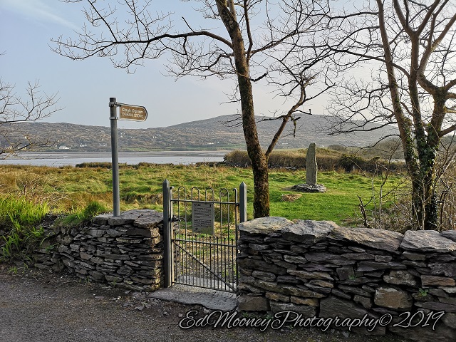
Next up on a walk about of the IFSC and Docklands in Dublin, I happened to come across a rather interesting structure for want of a better description. Straight away my mind wandered back to the numerous ancient Stone Circles that I have visited over the years. These were unique places that had an energy to them and were enjoyable to visit.
This structure is a lot more uniform, with each one of the 16 pillars placed at an equal distance in a perfect circle. Set in the middle of a small garden area with office blocks on three sides and George’s Dock on the other. Its quite pleasing on the eye and I will be returning for a night shoot. Light up, I reckon it would look even better after dark.
Obviously, this was one of many Statue’s & Sculptures that scatter the now well-developed Docklands region. But too my surprise whilst every other structure has some degree of information available, this has nothing, which only stirred my interest. Despite spending almost, a week scouring I could find no mention of the stones. I have reached out to the IFSC, but as of today have not recieved a reply. Am I getting old and Rusty? Or is there something else too this story?
Things got even stranger, when exploring the area on Google Maps, the shape of the pathways around the structure jumped out at me. They appear to be extremely similar to several different well-known symbols! Go on, have a look for yourself. Are we looking at a modern version of a Victorian era folly? Or is this something else? Tell me in the comments what you see. Or if you can shed any light on the structure itself, please feel free to share in the comments.
We as promised in my last post, I finally bit the bullet and hit the streets with my camera. Its been just over five years since my last posts from Kerry with the Darrynane Ogham Stone, a revamped Website & the Ringfort near CastleCove. And even longer since my last Ruinhunt expedition. So last Friday after work I stopped of in Dublin City center and took a good walk up along the North quays towards the Docklands. Not necessarily a Ruinhunt, I’d describe it more as Street photography perhaps?
Well, there was plenty that caught my eye, and no doubt there will be plenty of further trips around Dublin this year as I explore what’s on offer. For the moment, the days of driving all around the country are no more.
First port of call was The Harbourmaster Pub & Restaurant. Not very Ruins? I hear you say! Well, that may be, but it does have a cool history. Set in the heart of Dublin’s Financial Centre, this repurposed building was once, as the name suggests the old Harbour master’s Office for the Docklands. The original structure is said to have been built back in 1830. Then back in 2000 it was developed for its current use.
Just of Georges Dock, sitting right beside the inner dock, this unique structure really stands out despite its surroundings. For me it’s the three-level clock Tower that makes it so eye catching. I didn’t get a chance to stop off for refreshments this time, but I have enjoyed both the drinks and food on a few occasions. The inside contains both a bar & restaurant still retains an old-style interior. It gets quite busy as you can imagine but is well worth a visit if you’re in the area.
”Now let me see if I can still figure out how to do this blog thing”
Has it really been that long?
Those of you whom followed my Ruinhunting exploits back in the day might remember that I went through a number of unexpected life changes. But we have kept moving forward. If memory serves me correctly, my last event to shoot was Tallaghtfest back in 2015. This was where my trusty Nikon D40 sadly passed away halfway up St Maelruains Tower. Since then I relied on my reasonably sized archives to keep things going. Eventually all good things must come to an end and despite a small revival with a new website and the odd Ogham Stone & Ring Fort things finished up for me five years ago.
”Cmon Ed, Get too the Point”
So fast forward to 2023, Id been doing the ‘Gym Thing’ for a while when I happened too cross paths with a World Champion Powerlifter. Long story short, I was taken under the wing and taught the ‘Ways of the Powerlift’. All joking aside, I got to train with some of the best people around, and after a year & a bit, a few competitions, countless hours of training I’ve come to a place were parts of my old life and new have come together.
So last week I went out and acquired a new DSLR so I could take some shots for the Powerlifting Website that I try to help out with. Long story short, I went into this years National to compete in Equipped Bench and qualify for something later on in the year and I think I may have rekindled my buzz with photography. Got to shoot most of the day except when I was lifting. 1400 shots had to be whittled down to a respectable 305 🙂 You can check out the full Powerlifting gallery HERE.
Now I aint going to make any promises, will the Ruinhunter make a return? I cant say just yet, but I do reckon there will be more photography content in the not so distant future. Let me know what you think?
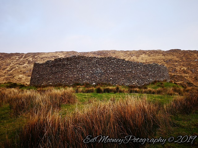
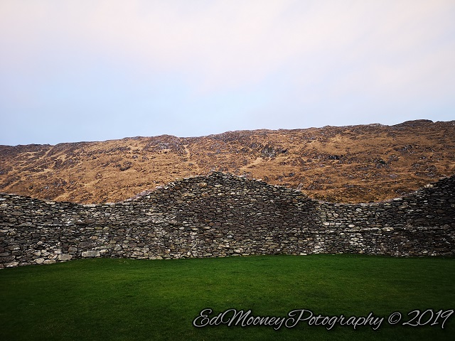
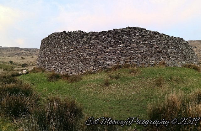
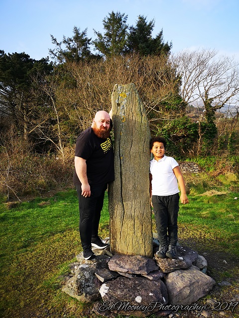
Kerry or ‘The Kingdom’ as it is also known, is a place very close to my heart. Having recently spent a few days down there. Eventually the plan is for the Ruinhunter to relocate to Kerry on a permanent basis. Aside from personal reasons, Kerry is also a Ruinhunter’s paradise. There are literally hundreds of fantastic monuments and ruins scattered across the landscape just waiting to be explored. And I am already plotting numerous sites to explore on my next trip. The last place I visited was a first of a kind for me. A Stone fort which is believed to date back to the Iron Age circa 300-400AD. Having only seen images of these stone forts previously, I was damn excited as we approached.
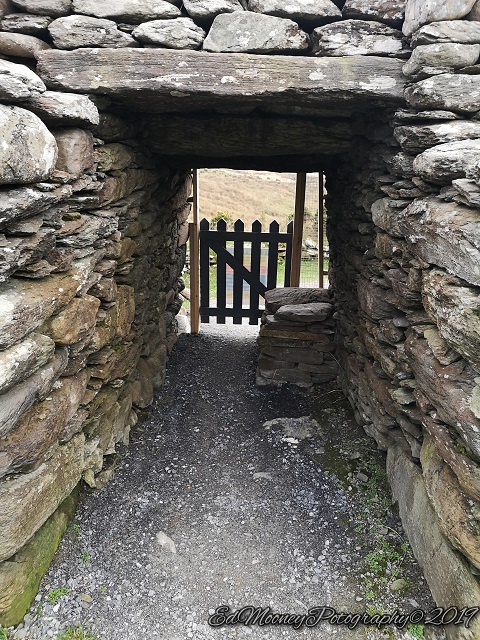
Located just off the Ring of Kerry not too far from CastleCove. The fort resides at the head of a valley on the Iveragh Peninsula, and certainly did not disappoint. On the path which leads up toward the Fort there is a gate with two rather amusing signs, instructing that all visitors must pay a Trespass fee to enter. 😊 At some stage a rather clever individual left a response in permanent marker on the notice. Now I never condone such acts of graffiti. My motto has always been ‘Leave nothing behind but footprints’. But the message does raise a rather interesting point. But that’s an argument for another time. As we approached the fort it was obvious that there were some repair works going on. And it looked like we might not have been able to get inside this magnificent structure. But Ive never been one to be deterred so easily and we proceeded up to the entrance. There was a wooden gate blocking the doorway with a site notice. The bolt was unlocked, so as my SAFE pass is still in date I didn’t see any issue in entering and we closed the gate behind us.
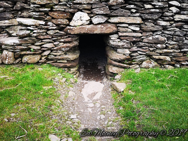
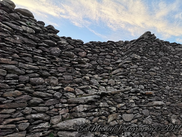
Once inside its amazing, you can almost visualize what is was like to live here 1600 years ago. There are signs outside the fort of a fosse and external bank which would most likely have been protected by wooden fencing. The Lintelled doorway leads you into the fort which walls are extremely impressive. There about 4 meters thick and are said to have been 6 meters in height although not all of the wall currently reaches this height. Built entirely from uncoursed stone, no mortar was used in the construction. There are two small chambers built into the walls, most likely these would have been used for storing foods etc. around the inside of the wall are a few twin stairways which lead up to the top of the rampart. The Fort itself is about 30mtrs in diameter and would have contained within its walls, a number of smaller structures and dwellings which sadly no longer exist.
I’m afraid my images really don’t do this site justice, I must invest in a drone for visiting these types of monuments to show how amazing they really look. Best I could do was a panoramic video from inside the fort which you can see HERE. Its generally believed that this would have been a defensive stronghold for a local chieftain. It certainly would have kept him and his clan safe from the wild beasts that once roamed these lands and from and would be attacks by other clans. But there is more to this story, nearby there is strong evidence to suggest that copper mining took place in the surrounding area. Was this the home of these miners? That’s one thing that intrigues me about these places. A lot of our answers are just guess work. It could to be honest served as a place of worship, a trading post, observatory or a defensive outpost. The truth is we just don’t really know.
For these and more of my images, why not visit myWebsite
After some recent unplanned Ruin hunting down in Kerry, I have finally caught the bug again. Since my last post on theOgham Stoneat Derrynane, I have been spending alot of time working on a new website. The old Ed Mooney Photography site is no more and currently resides in a recycle bin somewhere. So I got to start from scratch and went for a cleaner look. Its focused solely on my Ruin hunting activities with less clutter, although I will update as I continue to visit new sites over the coming months. Over the last few years I have had quite a bit of interest in selling prints, so in a few weeks once a suitable supplier is found a selection of my images will be available for sale from the website. Which should go somewhat towards financing further explorations along the West coast of Ireland. So without further adieu, I am excited to introduce to you the new and improved Website, I hope you like it 🙂
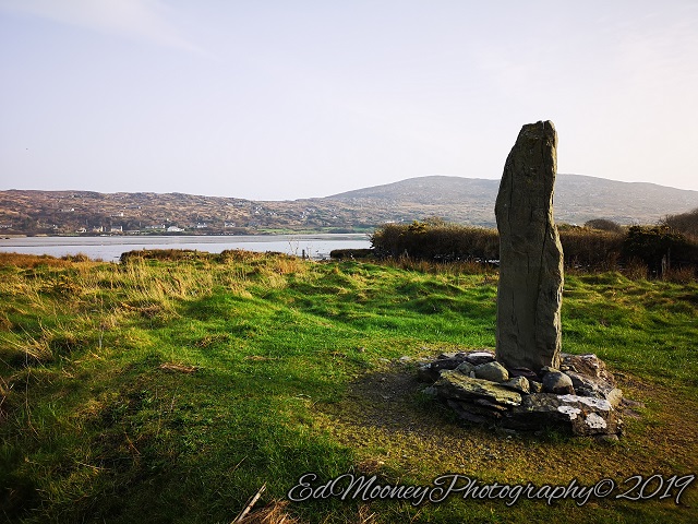
On a recent trip to Kerry I got the opportunity to do a little sightseeing and temporarily resurrect ‘The Ruinhunter’ 😊. I’ve missed exploring over the last few years and although I have no immediate plans to resume on a regular basis, the passion is still there and I wanted to share my experience with you. I will eventually return too my endeavors but current circumstances don’t afford too many opportunities. So, until this changes I will endeavor to post when and where the opportunity arises. First up was a rare favourite find of mine, An Ogham Stone, at Derrynane in Co. Kerry, also known as the Caherdaniel Ogham Stone, or by its Gaelic name Cloch Oghaim Dhoire Fhíonáin Beag, it is said to date back to 500 – 550A.D. This is only the 3rd, well fourth Ogham stone I have encountered if you count the two found in Ardmore. The first I found way back in 2014 at Donard.
Ogham is basically a 25-letter alphabet which is said to be based on the Roman alphabet. It is believed to be the earliest known form of writing in Ireland, which dates to approx. 4th century A.D. and was in use for around 500 years. This alphabet is made up of twenty-five characters which are represented by a series of straight or slanted lines. In early Christian times the Ogham Stone appear to have been used as commemorative stones, normally to mark someone’s final resting place or as boundary marker. Interestingly Ogham is sometimes referred to as the “Celtic Tree Alphabet” as many of the characters relate to the sacred trees of Ireland. Want to know more? Check out a fantastic piece ogham-the secret code of our ancestors by fellow blogger Ali Isaac.
According to the National Monuments Service the stone was uncovered under water on the Derrynane strand before being moved to its current location by the Office of Public Works back in the 1940’s. It’s quite easy to find the stone and is clearly signposted from the road. The stone itself as you could imagine is extremely eroded, no doubt from spending who knows how long submerged under water. The stone stands at over 2 meters in height and is made from Sandstone. Sadly, erosion makes it almost impossible to decipher the inscription, however having read the stone, R.A.S. Macalister in his (Corpus Inscriptionum Insularum Celticarum, 1945) gives us the following ‘ANM LLATIGNI MAQ M[I]N[E]RC M[UCOI] Q[…]CI’. As you can see much of the inscription was missing even back then. The only translation I managed to find was from Wikipedia as follows, (“name of Llatigni, son of Minerc, of the tribe of Q…ci”).
Despite the fact that this sheds no light on the historical significance of the stone, it still remains for me a fascinating piece of our heritage and history. Which is now thankfully subject to a preservation order.
For these and more of my images, why not visit myWebsite
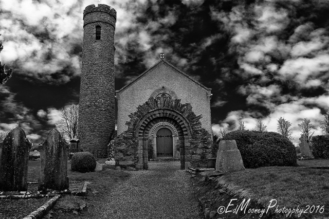
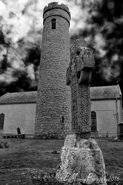
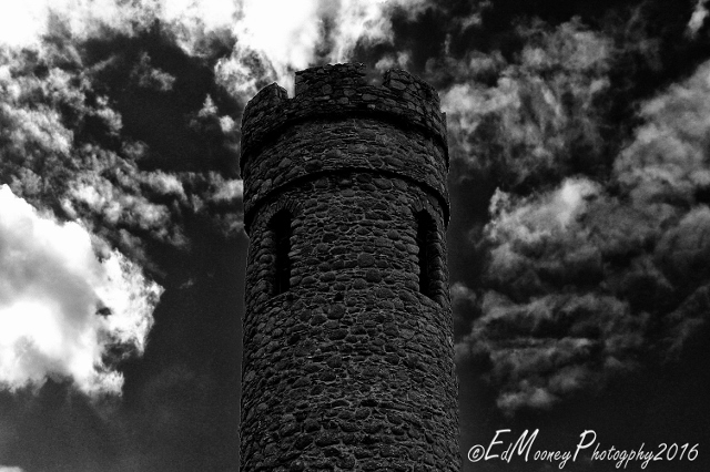
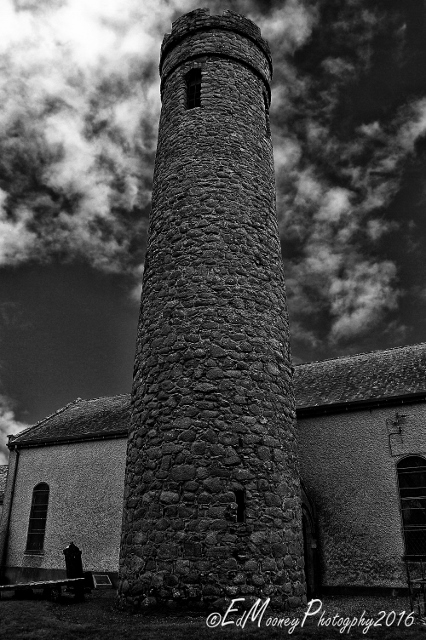
Continuing on from a previous post on Castledermot we continue on from the Romanesque Archway on the grounds of St. John’s, and move on to the Round Tower. Round Towers can be found all over the country in various states of ruin. But back in their day they would have Im sure held a massive influence over the lands on which they stood. There are many of these structures to be found around the country and each one that I have visited to date always seems to have its own unique differences. The Tower at Castledermot which is believed to have been built in the 10th Century is certainly no exception. Round Towers were commonly built on the West side of churches however here we find it lying to the North of the church. Perhaps an earlier church from around the time of the tower once stood in a different alignment? Or is there another reason for this deviation? Some of the information about the great history and archaeology of this great site comes from the guys at Abarta Heritage. Please take a moment and check out the link at the end of this post where you can hear the story for yourself with their free audio guides.
The other strange thing you may notice about this Tower is the fact that not only is it built very close to the current church, or should I say that the church was built very close to the tower as the Tower was constructed long before its neighbour. Another irregularity is that the doorway seems to have been built at ground level unlike others where the entrance doorway would be located a couple of meters above the ground, and it was believed this was to afford the people inside some degree of projection. But this is now highly debated. Then we have the tower which is connected to the nave of the church by a small corridor, on the day I visited the church was closed so I was unable to have a look on the inside. Im sure that there are reasonable explanations for all these facts. Perhaps on my next visit to Castledermot I may find the answers!
The Tower itself is only about 20 meters in height so it is not as visibly impressive as say Glendalough or Kildare. But Castledermot is a treasure trove of interesting ruins and history, so and this tower is a part of that heritage. At some stage I can only assume that the conical roof, a standard feature of many of these towers was removed and replaced with battlements. Not a common feature, but there are a few of these around the country, such as the one at St. Brigid’s in Kildare. It was built using uncoursed granite with limestone pinning’s. It has five floors with medieval era crenellations above two string courses, but the floors do not correspond to the original levels. The entrance is strangely at ground level through a flat lintelled doorway. I was unable to see any sign of a doorway at height, so perhaps it never had one or the brickwork was matched carefully to the original. There is an arched window on the first floor, and a flat headed window between the second and third floors. The windows at the top, and the crenellations date from the sixteenth century. It is joined to the church by a vaulted corridor with wicker centring, of fifteenth century type. The tower itself appears to be in good repair and I will be definitely returning here to see if I can gain access to the inside and see what else I can find.
For these and more of my images, why not visit myWebsite
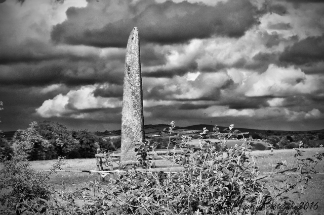
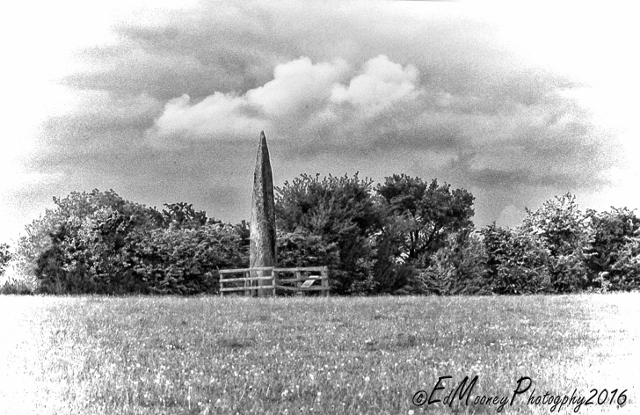
A short distance up the road from the Standing stone at Craddockstown we find what is possibly the tallest Standing stone in the country. It is definitely the tallest I have come across to date. I first spotted it driving up the old country road, peaking up over the hedgerow, it kind of reminded me of a obelisk from ancient Egypt. Unfortunately it is quite difficult to gain access to and despite numerous attempts to find a way in, nature’s natural barrier, kept this ruin hunter at bay on this occasion, so I had to settle for some shots from beyond the hedgerow. This massive stone which is more commonly known as the Long Stone of Punchestown Great, stands at about seven meters in height, with 1.5 meters of it underground, and appears to have an almost square base which gradually tapers at the top.. It is estimated to weigh approx nine ton, resides in a field adjacent the well-known Punchestown racecourse.
The long Stone is a National Monument which thankfully is under the protection of the Irish Government for whatever that is worth. Some years ago the land owner erected a small fence around the stone. I can only guess that this was done to stop livestock using it as a scratching post. From my experience animals seem to be drawn to these stones and will regularly use them to relieve that itch. You would not believe the amount of times I have found clumps of wool and other animal hair stuck on similar stones. It is said to have fallen in the early 20th century and was put back in place in 1934. During an excavation carried out at the time a small Bronze Age burial kist was found beside the socket, but it was apparently empty. Perhaps the Long stone was used as a grave marker back in ancient times, or was it erected for some other purpose?
The Welsh chronicler Giraldus Cambrensis spoke about many of Kildare’s standing stones in his Topographia Hibernica which was first published back in 1188 as follows:
Fuit antiquis temporibus in Hibernid lapidum congeries admiranda, quae et Chorea Gigantum dicta fuit; quia Gigantes eam ab ultimis Affricae finibus in Hiberniam attulerant, et in Kildarensi planitie, non procul a castro Nasensi, tam ingenii quam virium ope mirabiliter erexerant.
In ancient times there was in Ireland a remarkable pile of stones, called the Giants’ Dance, because the giants brought it from the furthest parts of Africa into Ireland and set it up, partly by main strength, partly by artificial contrivances, in an extraordinary way, on the plains of Kildare, near Naas.
— Gerald of Wales, Topographia Hibernica, Distinctio II Chapter XVIII.
I found this quite strange as there was no mention in any of the Annals of Ireland which mention Giants from Africa visiting our shores. In fact the only Giant that I know of was the Leader of our legendary Fianna, Fionn Mac Cumhaill whom was sometimes reffered to as being a giant? Well one tale tells that Fionn in a show of strength to his wife threw the longstone from his base on the Hill of Allen, and it landed at its current location Near Naas some which is some fifteen kilometres away as the crow flies. Whatever the truth is, I am sure we can all agree that this is is one magnificent monument, which you really need to see in person to fully appreciate the sheer size of the stone.
For these and more of my images, why not visit myWebsite
''Plan ahead and prepare, Be considerate of others, Respect farm animals and wildlife, Travel and camp responsibly, Leave only what you find, Dispose of waste properly, Protect nature from fire.''


You must be logged in to post a comment.